Scientists have launched a robops into the underground of Prague, which will help with a virtual map and research
Updates: 06/28/2022 13:23
Released: 28.06.2022, 13:23
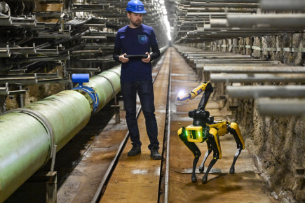
Prague – A robot used by scientists from the Czech Technical University (ČVUT) helped prepare a virtual 3D map of tunnels with engineering networks under Prague. In recent weeks, researchers sent an autonomous SPOT robot from Boston Dynamics equipped with a robotic arm underground. During a survey of a team of robots from the Faculty of Electrical Engineering (FEE) CTU, he also tested the movement of this “robops” underground and collected information for models of radio signal propagation. Representatives of FEE and Kolektory Praha presented the project in Prague today.
Jan Faigl from FEE said today that the underground offers several interesting challenges for robots. Tens of meters below the surface of Faigl, on the one hand, there is no access to GPS and the robots have to orient themselves only through data and sensing the environment. Communication is also not possible there. “When a robot moves far, it must basically be completely autonomous. Or build that communication structure,” the scientist said.
According to many sensors, the robot creates a map, which can then be used to prepare virtual tours. “The advantage of a robot with a robotic arm is that it has a camera in its hand and is able to look at some interesting things. For example, following a line and an engineering network,” Faigl described, adding that the robot can also be used for control.
The scientist also noted that the appearance of tunnels with engineering networks, so-called collectors, all available to collect data using a robot, on the basis of which scientists build models to predict signal propagation. Faigl rescues that there are cases, such as missions in caves, where it is necessary to build a communication infrastructure directly in the problem area in order for the robot to return from the reconnaissance mission and provide the necessary information.
Regarding the current survey, Faigl told ČTK that it took place in the spring in three two-day cycles. According to him, the robots have traveled in the order of kilometers, part of the data is still being evaluated by the FEE team. According to Petr Švec, Chairman of the Board of Directors of Kolektory Praha, there are over 93 kilometers of collectors under the capital, and about 20 kilometers below the center of Prague.
The public cannot collectors at present. The prepared digital 3D map is intended to serve both laymen for the inspection of inaccessible tunnels, as well as experts for the completion of the GIS collector system and technical maps of Prague.
Barbora Švecová then told ČTK on behalf of Kolektory Praha that an interactive map of three different places was being prepared. The first mapped place will be from the deepest collector in Prague, which is about 30 meters below the surface, the others will be from the subsurface collector and the collector, which is located directly below the Prague sidewalks. Švecová pointed out that she could not reveal specific places, as it was a strategic infrastructure.
Two robots with a robotic arm were only recently acquired by a team from FEE, sending one of them underground. However, the first self-walking robopes strengthened the faculty group of robots last spring. Among other things, scientists are trying to further improve their sensory abilities and participate in competitions with purchased robots.