Map shows how warm it is on New Year’s Eve in Austria – Weather
The warm front reaches an Atlantic low at the beginning of the weekend in Austria, after which a sustained south-westerly flow sets in over the weekend. This makes it exceptionally mild for the time of year, especially at medium altitudes. The temperatures will rise to around 20 degrees – and even on New Year’s Eve there will be no sign of winter or even snow.
“Much too warm” – New Year’s Eve with record temperatures
But how warm will it really be at the turn of the year and what will happen afterwards? “Today” wanted to know exactly and asked UBIMET expert Konstantin Brandes. And so much can already be revealed at this point: Austria is definitely one of the “hottest” countries and “hotspots” in Europe these days.
“Today“: What is the reason for the unusual temperatures?
Constantine Brandes: “Around the turn of the year the air masses come from the southwest, a few days ago the air was still over the subtropical Atlantic and is accordingly warm. In general, Central Europe has the warmest air mass that is possible at this time of year, see also the temperature deviations on tomorrow, Saturday, throughout Europe in the appendix. Widespread maximum values are 10-15 degrees above normal, locally (Eastern Germany/Poland) even up to 20 degrees above the seasonal average, warm air masses sometimes penetrate to the ground and not only limit to height.”
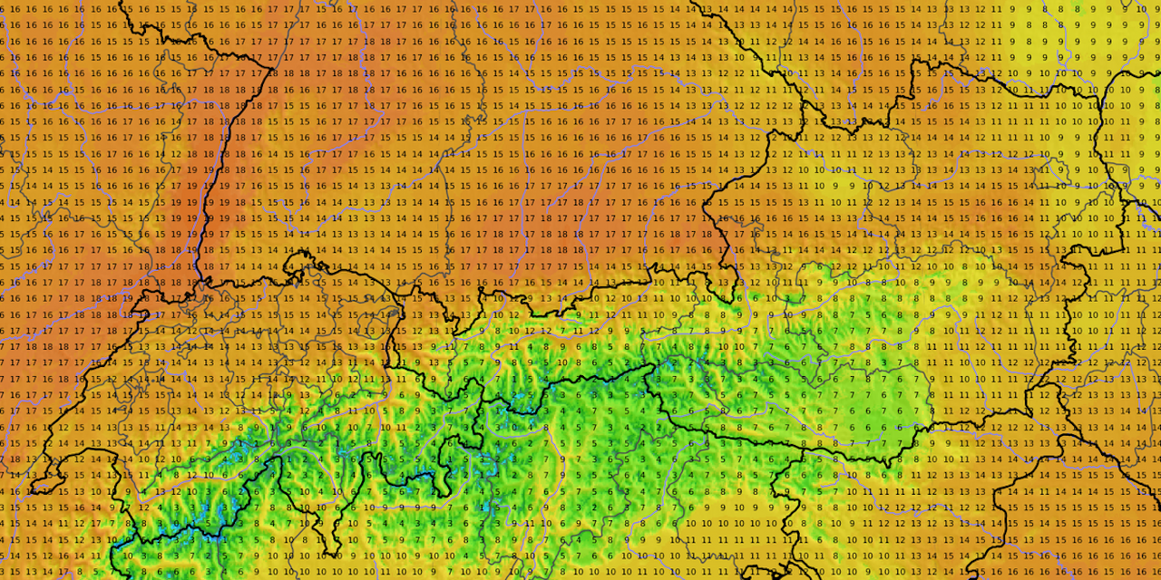
Where exactly will it be warmest on New Year’s Day?
Saturday has a few hours of sunshine to offer, and the local light rain in the north and east will subside by noon and it is increasingly loosening up everywhere. With a briskly freshening south wind and a föhn wind on the north side of the Alps, temperatures will rise to between 9 and 18 degrees, only from the Lienz and Klagenfurt basins to the Upper Mur Valley will it remain cooler in places with values around 5 degrees. The highest values, namely 15-18 or even 19 degrees, are found at slightly higher altitudes in the northern Alps from Vorarlberg to the Vienna Woods and the eastern edge of the Alps. Among other things, the city of Salzburg should be a hotspot.
New Year’s Eve is then generally dry and exceptionally mild, especially in low mountain ranges. At midnight, the temperatures are widely scattered between -3 degrees in some Alpine valleys (Lungau), +7 degrees in Vienna’s city center and +15 degrees in exposed hilly areas of the Alps and the Waldviertel.
What is the weather forecast for New Year’s Eve in Vienna?
On Saturday, New Year’s Eve, there will initially be dense clouds over the city and a few raindrops will fall occasionally. In the afternoon it starts to loosen up and the sun can still be seen from time to time. In addition, temperatures will rise to 8 degrees east of the Danube and up to 12 degrees in the western outskirts. It gets even milder on the peaks of the Vienna Woods with around 17 degrees at an altitude of 600 meters. New Year’s Eve is then often clear at first, and the tendency to fog increases in the second half of the night. The sky should still be slightly cloudy for the fireworks at midnight. At midnight, around 5 degrees are expected in the eastern districts and around 10 degrees in the Vienna Woods.
What will the coming days look like then?
Am Sunday New Year, the sun often shines. In the lowlands, in some valleys and in the southern basins, it is foggy in some areas, but the dull gray usually dissolves during the day and it becomes friendly. Towards evening, however, there will be more high fog in the east. On the main Alpine ridge it is still föhn, brisk southerly winds are also blowing in the east and south-east and with 6 to 16 degrees it remains very mild for the time of year.
Of the Monday offers a few hours of sunshine, especially in the mountains and in the south-east. In the Danube region and in the eastern lowlands, fog and high fog usually persist, in the west it draws in towards evening. But it’s still dry. The foehn dies down, the wind is usually no longer an issue. Only in the very south-east will there be moderate to brisk south-west winds. Depending on the fog resolution, the temperatures reach 4 to 14 degrees.
Am Tuesday the clouds predominate, in the beginning there is still fog in the lowlands. It rains at times, especially along and north of the Alps, and the snowfall line drops to around 1,000 meters over the course of the day. In the Mühlviertel and Waldviertel, a few snowflakes fell down to 800 meters in places. A moderate westerly wind blows in the Danube region and in the east. The maximum values are between 3 and 11 degrees.
Trend until January 6th: The onset of winter, complete with snow and cold, is far and wide not in sight; on the contrary, it remains much too mild throughout the week. The maximum values are clearly in the plus range, the 10 degree mark is regularly torn and up to 15 degrees are occasionally possible during the course of the week. As a result, the lack of snow in the Alps is getting worse.
Will Austria become one of the “hottest” countries in Europe these days?
Austria and especially the northern side of the Alps will definitely be among the hotspots tomorrow, but then less so. But as mentioned, it is much too mild in large parts of Europe, the temperatures are more suitable for April than for the turn of the year. Here is a small selection of the maximum values at the turn of the year:
Salzburg 18°
Munich 19°
Paris 17°
Bilbao 22°
Romans 18°
London 14°
Zagreb 17°
Prague 17°
But also +7 degrees in Stockholm and +6 degrees in Helsinki are remarkable for this time of the year. Apart from the Canary Islands, the absolute hotspots for New Year’s Eve in Europe are the hinterland of the Spanish Mediterranean coast with up to 24 degrees!