Pisa, Grosseto, Arezzo, Florence and Siena the most affected provinces – INTENSE RAIN, HIGH PRECIPITATIVE RATES
WEATHER TUSCANY RAIN. It continued to rain relentlessly especially between the provinces of Pisa in its southern part, Grosseto and Siena especially in the area around the Metalliferous Hills. Semi-stationary thunderstorms charge from the coast between San Vincenzo and Piombino and then bring intense rains in the immediate hinterland leaning against the hills.
Rains also meant the provinces of Arezzo and Florence, albeit to a lesser extent.
There are several locations where more than 50 mm fell in two hours but we had peaks of more than 80 mm in less than two hours.
The trend now sees a slow lowering of the main precipitating fulcrum with a partial improvement which will then advance from the north. Tomorrow morning the situation is expected to be calmer throughout the Tuscan territory.
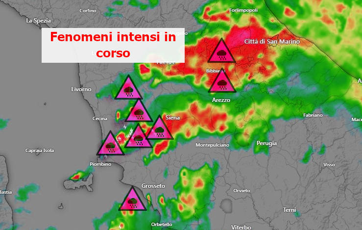
At the moment the most active convergence line is traceable from Elba, passing through Siena and then towards Arezzo. The most intense precipitative phenomena move along this imaginary line and are more abundant on the part closest to the sea.
The northern provinces with decidedly modest rainfall throughout the day are almost completely skipped.
On the other hand, rains that have intensified in the last 2, 3 hours also in the province of Florence.
The central belt of Tuscany is therefore for the moment the area in which the rainfall has been the most, bringing very abundant millimeter accumulations.
The situation is well summarized by the graphic framework of the Tuscan Functional Center:
For the moment, despite the large amounts of rain, we have no reports of particular inconveniences. And this can only please you.
For all reports in real time, send for your photos, subscribe to the Meteo Toscana Telegram group!
https://t.me/+1kcB3gY_R4QzNDhk
Or subscribe to the channel to be always informed!