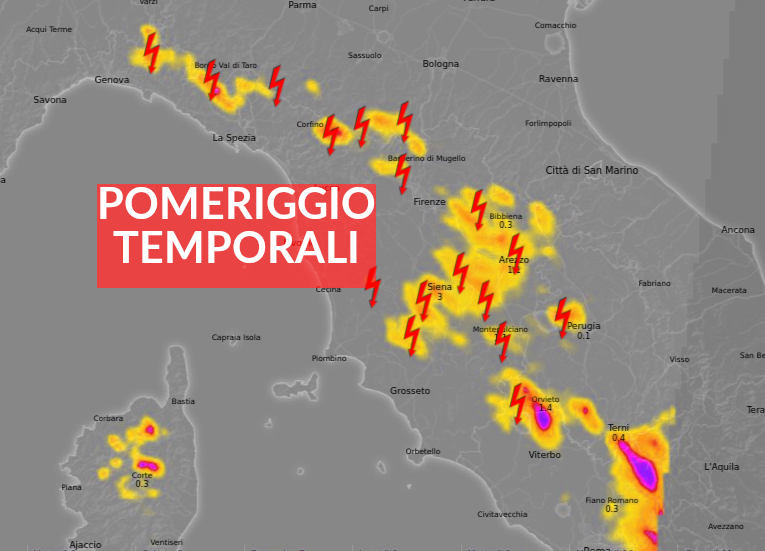
TEMPORALS, MOST PRESENT IN THE AFTERNOON IN THE INNER AREAS OF TUSCANY province of Siena, Arezzo, Grosseto and the Apennines
WEATHER, TEMPORALS IN TUSCANY. As expected, the morning shows signs of greater instability: irregular clouds and a storm cell in action near Prato on the Apennines moving towards Mugello.
It will be in the same areas of the hour that the thunderstorms will move to a greater extent on Tuscany with a preference for the Apennine belt, as an indicator on the map, of the central and southern regions. The provinces of Siena, Arezzo and Grosseto remain the favorites for the afternoon thunderstorm evolution in addition to the whole Apennine area.
Rather isolated thunderstorms but which locally will also be of moderate intensity with accumulations of a certain degree.
The risk of developing convective cloud cover close to the coasts is decidedly low, where instead the breeze will activate from mid-day.
The temperatures will, however, be decreasing by a few degrees throughout the territory, either due to the lower amount of sunshine or to the slight drop in the isotherms at high altitude.
The situation is then destined to improve rapidly starting from the evening with the promise of sun and rising temperatures for tomorrow.
Details will follow.
For all reports in real time, subscribe to the Meteo Toscana Telegram group!
https://t.me/+1kcB3gY_R4QzNDhk
Or subscribe to the channel to be always informed!