This is how it has been during the joint holiday: Meteorologist comes with a warning
In June, we could boast of some hot, summery days. The meteorologist is not as optimistic about the July weather in Norway.
– The start of the joint holiday is low-pressure. Low pressure often causes clouds and precipitation. It will thus be unstable weather throughout Norway in the future, says on-duty state meteorologist Eirin Walstad Ristesund.
Ristesund sees no signs of a high-pressure situation, and we can therefore imagine precipitation a little off and on for some time to come.
She says that the further ahead in time we go, the more uncertain the weather forecasts become.
– A lot can change in the future. But I see no signals that there will be stable weather conditions. The weather will generally be variable, she says.
Unstable summer
Photo: Private
Those who are going on a Norwegian holiday can unfortunately not rejoice over a hot and dry summer. More suggests a typical Norwegian summer, with slightly unstable weather, and with some sunny days in between.
The meteorologist points out over the next few days that the low pressures are mostly coming from the east, which can give a lot more precipitation in places that are not so used to a lot of rain.
According to tradition, Eastern Norway will have more stay-at-home weather than Western Norway, Trøndelag and along the coast. Eastern Norway gets the best summer weather.
The meteorologist points out a bright spot in the coming weather situation.
– It does not look like there will be any special low temperatures in the future. The temperature should generally be slightly up. Eastern Norway will experience having around 20 degrees, also it will be gradually cooler up to the north. Sørlandet can expect around 20-25 degrees in the future, says Ristesund.
– We will probably not see the same trends high temperatures in Tromsø. It was a very special situation in Tromsø in June. But I see that it may indicate to be up to 20 degrees occasionally in the north. I do not see a prolonged tropical heat, she adds.
Climate researcher Eirik Kolstad, looks into his long-term forecasts that August may be warmer than normal, than that July will be. He also lays down guidelines for there being more precipitation than normal in southern Norway.

Ristesund will not comment on the weather in August, because it is difficult to predict the weather so far in the future.
– A lot can change in these weeks ahead, she says.
Also read: Norgesferiens elite division
Advises everyone to check the weather forecast regularly
Ristesund comes with clear advice for everyone who is going out into nature.

Photo: NCEP
– Due to the low pressure weather situation in the future, a lot of wind can occur. The risk is greatest at Trøndelag and further south. It suggests calm and summery wind conditions at first, but that may change. There may be a gale, and I would therefore encourage everyone who is going out on a boat, tent, mountain hike or similar, to check the weather in advance. Especially due to the unstable weather conditions.
Ristesund sees no signs of a pronounced storm for the next two weeks.
– In northern Norway, it is perhaps a bit like times when we enter an unstable period, with a little more wind and precipitation than elsewhere in the country. But there is nothing flashing danger to thunder and lightning for me now. The situation is «good». The next few days the temperature may be a little low, but it will pick up to “normal”, she informs.
– I encourage everyone who loves the sun and heat to enjoy the nice days that are this summer. This summer offers no guarantee of long-lasting good weather. Get out in the boat, on the beach or the campsite when the weather is nice, because it will be good weather, it just will not be stable and long-lasting, she adds.
A danger warning has also been sent out for forest fires in Telemark and eastern parts of Agder.
– Forest fire danger occurs when it has not rained for a while. The vegetation becomes drier and more flammable. If there is wind in addition, the danger increases, and forest fires can spread quickly in dry terrain if it is windy. The danger of forest fires persists until there is some precipitation. A rule of thumb is that there must be 10 mm of precipitation over a larger area for the risk of fire to decrease significantly, informs Ristesund.
For those who are going abroad, the hope is greater for warmer and more stable weather
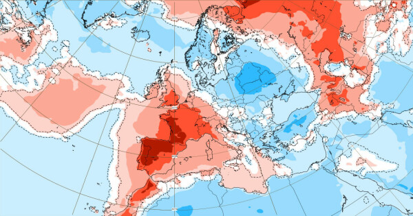
Heatwave in Spain and Portugal
She warns strength to high temperatures in Portugal and Spain.
– Spain and Portugal will get a heat wave in the next few days. It will be up to 40 degrees. Those who are most exposed are in the western parts of Spain, but also the Portuguese will experience very high temperatures, although they will get a little more cold air from the Atlantic than what the Spaniards get, says Ristesund.

Photo: Screenshot Yr.nr
Spanish Meteorological Institute AEMET has sent out a strong warning to the inhabitants.
The highest recorded temperature on Sunday was 43 degrees, which was measured by the Guadalquivir River near Seville in southern Spain and in Badajoz, in the west of the country, writes the Spanish Meteorological Institute AEMET.
– This heat looks like it could continue for the next two weeks. This is a very unusual situation for Spain. It is expected that it can be up to 46 degrees in some places, says Ristesund.
Seville, Madrid, Salamanca and Granada are exposed to high temperatures in Spain.
– It does not look like hot on the east coast, in the typical Norwegian holiday towns, Ristesund points out.
Denmark
– It is a high pressure that is building up over the UK that will benefit Denmark. It therefore looks like Denmark is characterized by stable and dry weather in the coming weeks, informs Ristesund.
You can expect over 20 degrees all over Denmark. Weather winners in Denmark are cities in the southeast of the country.
– If you are going to places like Copenhagen and Odense for example, then you most likely have good weather waiting. We generally have a slightly unstable weather situation in the world, so one should not rule out a little rainfall sometimes. But it appears to be quite stable and fine, says the meteorologist.

Photo: Getty pictures
Also read (+): ‘Line, we have to talk about the holidays. It will not be as usual, “he said. Then came the truth
Danger of heat wave in the UK
This high pressure over the UK poses a possible risk of heat wave with «record temperature» in several cities in the south-east of the UK.
Meet the office has sent a yellow warning of high temperatures in the coming weeks. Next week, the degree may go above 40 degrees for the first time in British history. The highest temperature recorded in the UK was 38.7 degrees in Cambridge in 2019.
Italy, France and Croatia
– In these countries, it looks like it will be an ordinary summer. The weather is hot, dry and stable.
– In western France it seems to be high temperatures, but not to the extent as in Portugal and Spain. The same high pressure that provides stable weather in Denmark in the next few days, with which the warm air from the Iberian Peninsula north to France and southern England. They are located in the same air mass as Spain and Portugal. They will know a little about the high temperatures, but not to the same extent as the air cools a little on the trip north over the sea.
– In the North and on the coastline of Croatia, there is a lot of wind. This can be an obstacle for those who are on a boat, but otherwise it can be perceived as a slightly cooler gale for those who fry in the summer heat. The wind will not persist for a long period.
Lit also: So much sun can the children withstand
Greece
– In Greece it looks like it will be fine weather. But it seems that there may be some storms and thunder in the future, but not to the extent that it should ruin the holiday.
– Periods of thunder, especially in the afternoon, are very common in southern Europe in summer. The thunderstorm they get down there is usually much more spectacular than we experience here at home. It does not look like there will be any storm that is very unusual or that stands out, says Risteund.
:quality(70)/cloudfront-eu-central-1.images.arcpublishing.com/mentormedier/N6RJLCI6SW7WCAQ5O7UDUCPGQY.jpg)