Bad Hope: It’s snowing in Athens, it spread in the northern suburbs – Which roads are closed in Attica
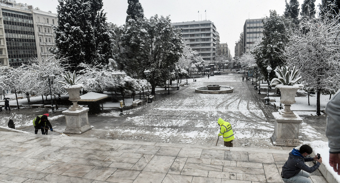
Arrived at a little earlier than expected Attica the bad weather Hope, as it started to snow shortly after 8 in the morning in the northern suburbs and until this time the first flakes are falling in the center of Athens.
Already in Kapandriti and Malakasa everything is covered by snow while on the Athens – Lamia National Road the snowplows have not stopped working to keep the road open.
Snow at this time in Maroussi, Kypseli, Polygono and Ampelokipi, while the snowfall is denser in the north of the prefecture, in Agia Paraskevi, Vrilissia and Melissia.
Where the traffic has been stopped in Attica – ELAS: No to unnecessary transportation
- ΣTHN OΔO ANAΣTAΣEΩΣ (ΠΑΠΑΓOY) KAI ΣTA ΔYO PEYMATA KYKΛOΦOPIAΣ ΑΠΟ ΤA KOIMHTHPIA ΠΑΠΑΓOY ΠPOΣ TON YMHTTO.
- ΣΘ Λ.
- ΣTHN ANΩNYMO OΔO (KAIΣAPIANH) KAI ΣTA ΔYO PEYMATA KYKΛOΦOPIAΣ ΑΠΟ TO YΨOΣ THΣ KAΛOΠOYΛAΣ ΠPOΣ YMHTTO.
- ΣTHN ΛΕΩΦOPO ΠAPNHΘOΣ ΑΠΟ TO YΨOΣ TOY TEΛΕΦEPIK KAI ΣTA ΔYO PEYMATA.
- ΣTHN OΔO ΔIONYΣOY ΑΠO TO YΨOΣ TOY 414 ΣNEN ΠPOΣ TON AΓ. ΠΕΤΠΟ.
- ΑΠΑΓOPEYΣH THΣ KYKΛOΦOPIAΣ TΩN ΦOPTHΓΩN ΣTHN Π.EO AΘHNΩN – ΘHBAΣ APO TO YΨOΣ TOY ΠPATHPIOY YΓPΩN KAYΣIMΩN CYCLON PEYMA ΠPOΣ ΘHBA.
At the same time, their circulation was banned heavy vehicles in the news Athens-Lamia national road, in the stream to Lamia, from the height of the Kalyftaki bridge and from the Inofyta junction in the stream to Athens. The rest are driven using anti-skid chains.
At the same time with its extraordinary announcement, its headquarters Hellenic Police Recommends to the citizens, who live in Attica and especially in the northern suburbs, where there is heavy snowfall, as well as in areas throughout the territory, where extreme and extreme phenomena occur, to avoid any movement.
Bad weather Elpida: All the municipalities of Attica are on foot
The whole mechanism of Local Government in Attica is on foot. The bad weather Elpida is coming, the snow is falling and most of the areas of the prefecture are already dressed in white.
The services of the Civil Protection of its municipalities Attica are in full readiness and in constant cooperation with the Region, so that they rush immediately where a problem occurs or is reported. Snowplows take to the streets and work to keep the main road network open, although already in the municipalities of the northern suburbs the snowfall is heavy as it has been laid and therefore constant recommendations are made for careful and not pointless movement.
At the same time, the Social Service of the municipalities is on full alert to offer any assistance to the vulnerable groups of the population. The municipalities have announced the points that operate as heated spaces, for any citizen the environment, but also for the homeless. Post the phones, where one can turn for help in case of need or to report an event.
All the municipalities of Attica tons of salt have been procured, with which they supplied the inhabitants and it is still at their disposal today.
Finally, the municipalities invite the residents to be informed about the recommendations of the General Secretariat for Civil Protection and in each case to faithfully follow its instructions.
Watch live the evolution of the bad weather Elpida
The weather today Monday 24/01 / 2022- Detailed forecast
Snowfall in dense places, initially in the central and northern Aegean, Evia, and gradually in eastern Thessaly (mainly Magnesia) in eastern Sterea, and in the evening in the eastern Peloponnese, the Cyclades, Crete.
The winds will blow north northeast 5 to 7 and gradually in the eastern continents and in the central and northern Aegean 8 to 9 Beaufort. In the Dodecanese will initially blow east southeast 5 to 7 Beaufort and from the evening west northwest with the same intensity.
The temperature will be kept at very low levels. Frost will occur on the mainland, which will be strong in places in many areas of the north while in the northwest which is total.
MACEDONIA, THRACE
Weather: Temporarily increased clouds with temporary snowfall mainly in Halkidiki.
Winds: North 4 to 6 and east northeast 7 Beaufort.
Temperature: From -05 (minus 5) to 04 degrees Celsius. In western Macedonia from -13 (minus 13) to -01 (minus) degrees Celsius.
IONIAN ISLANDS, EPIRUS, WESTERN STEREA, WESTERN PELOPONNESE
Weather: Temporarily increased clouds with temporary local snowfall
Winds: Northeast 4 to 6 Beaufort.
Temperature: From -02 (minus 2) to 08 degrees Celsius. In Epirus from -06 (minus 6) to 05 degrees Celsius.
THESSALY, EASTERN CENTRAL, EASTERN PELOPONNESE
Weather: Cloudy with snowfall that will be dense in places initially in the Sporades, Evia and gradually in eastern Thessaly (mainly Magnesia), eastern Sterea and in the evening in the eastern Peloponnese. Gradual weakening of the phenomena in the morning hours of Tuesday and from the north. In the eastern sea and coastal areas, local storms occur.
Winds: North northeast 7 to 8 and gradually locally to the east 9 Beaufort.
Temperature: From -01 (minus 1) to 05 degrees Celsius, while in the north it will be 3 to 4 degrees lower.
CYCLADES, CRETE
Weather: Cloudy with sleet or snowfall which will gradually intensify, and will continue for most of Tuesday.
Winds: From north 4 to 5 and west 5 to 7 Beaufort. Gradually it will strengthen to 6 to 7 and locally to the west 8 beauforts.
Temperature: From 00 to 09 degrees Celsius.
EASTERN AEGEAN ISLANDS – DODECANESE
Weather: In the islands of the eastern Aegean clouds with snowfall which have in the morning during the periods that are dense. In the Dodecanese, clouds with sleet and snowfall in the mountains that will intensify at night.
Winds: In the islands of the eastern Aegean northeast 7 to 8 and gradually 8 to 9 Beaufort. In the Dodecanese east southeast 5 to 7 beauforts gradually westerly northwesterly with the same intensity.
Temperature: From 04 to 10 degrees Celsius, while in the north it will be 4 to 6 degrees lower.
EUBOEA
Weather: Cloudy with snowfall, which at times is dense. Weakening of the phenomena from the pre-noon hours of Tuesday.
Winds: Northeast 7 to 8 and gradually locally 9 Beaufort.
Temperature: From -01 (minus 1) to 04 degrees Celsius.
ATTICA
Weather: Cloudy with snowfall that will intensify from noon. Weakening of the phenomena from the pre-noon hours of Tuesday.
Winds: North northeast 6 to 7 and in the east local 8 Beaufort.
Temperature: From 01 to 04 degrees Celsius. In the north 2 to 3 degrees lower.
THESSALONIKI
Weather: Temporarily increased clouds with temporary snowfall mainly in the south.
Winds: From north 4 to 6 beauforts.
Temperature: From -02 (minus 2) to 03 degrees Celsius.
The weather all week
TUESDAY 25-01-2022
In the west and north a few clouds are forecast temporarily increased with temporary sleet or snow. In the rest of the country, clouds with sleet and snowfall are forecast in places dense in the southern parts of Thessaly, the Sporades, Evia, eastern Sterea, eastern Peloponnese, Cyclades and Crete, but the effects from the morning and from the north. weaken and at night in Thessaly and the eastern Peloponnese to stop.
The winds will blow northeast 5 to 7 and in the Aegean 8 to 9 Beaufort and from noon north with a slight weakening. The temperature will be kept at very low levels. Its maximum values will not exceed in the west and their islands 8 to 10 degrees and in the rest of the mainland 3 to 5 degrees Celsius while the minimum will fall in the mainland to -5 to -6, in the northwest to -15 and in the islands to 2 to 4 degrees Celsius. The frost will occur on the mainland, which will be strong in places while in the northwest it will be total.
WEDNESDAY 26-01-2022
In the western and northern continents generally clear weather with local clouds from the afternoon in the Ionian. In the rest of the country clouds temporarily increased with sleet and snowfall mainly in Evia and the southern Aegean, which until the evening will be limited to the southern regions.
The winds will blow from north, in the west 4 to 6 Beaufort, in the east 5 to 7 and in the southeast until the afternoon.
locally 8 beauforts, weakening at night from the northeast. The temperature will rise slightly to its maximum values
although the minimums will be kept low. In places at
There will be heavy frost on the mainland in the morning and in the evening.
THURSDAY 27-01-2022
In the mainland a few clouds temporarily increased. In the rest
increased clouds with local rains in the southern and eastern Aegean
and a little snow in the mountains of Crete. The winds will blow northwest 4 to 6 and in the southeast local 7 Beaufort with gradual weakening. The temperature will rise slightly further. In places frost
will occur on the mainland (mainly central and northern)
morning and evening.
FRIDAY 28-01-2022
Cloudy skies temporarily increased with local rains mainly in the west and
south and a little snow in the northern mountains. The winds will be from west 3 to 5 and temporarily in the south up to 6 Beaufort.
The temperature will rise slightly further. Occasional frosts will occur in the central and northern continents in the morning and evening.
SATURDAY 29-01-2022
Cloudy with rain in most parts of the country. Storms in
sea and snow in the mountains as well as in the semi-mountains of the central
and northern country. Winds will be westerly northwesterly 5 to 6 and locally in the seas 7 beaufort. The temperature will drop slightly from the north. Occasional frosts will occur in the central and northern continents in the morning and evening.