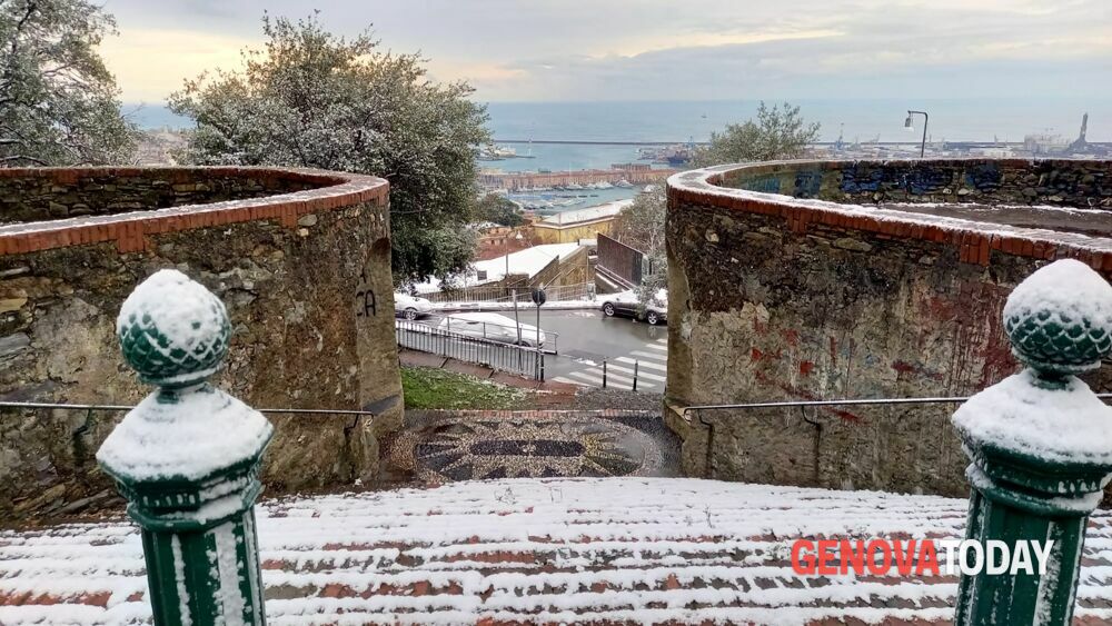
Snow warning in Genoa and Liguria on Wednesday 8 December 2021
Feast of the Immaculate Conception under the banner of bad weather in Liguria. As anticipated, precipitation is expected, even snowy ones, with some flakes that could also reach the coast between Genoa and Savona. Arpal has issued the weather warning for snow. The details:
- internal municipalities of zones A and B (west and center of the region): yellow from 8 to 18
- coastal municipalities of zone B: yellow from 10 to 15
- zones D and E (western and eastern Po slopes): yellow from 5 to 8 then orange until 15 then again yellow until 20.
After two sunny but rather cold days, the high clouds expected for the afternoon will herald the imminent change of weather conditions on Liguria. An Atlantic perturbation, in fact, will cause, already from the early hours of Wednesday 8 December, widespread and persistent weak rains with some local downpours.
The most important phase of the worsening is expected between the morning and the afternoon, with a thermal collapse that will cause snow in inland areas with a lowering of the snow level on the Po slopes and in the inland areas of the central sector and phenomena that will push behind of the coast, up to hilly shares; it is not excluded, where the orography and the thermal conditions of the air column will allow it, that you can reach the coast between the Genoese and Savona areas.
The accumulations will be substantial in the interior with particular attention, therefore, for the areas crossed by the motorway routes. In addition to the snow, the storm wind will be the protagonist, from sirocco to Levante, while there will be a north wind over the central Ponente. For a gradual attenuation of the phenomena it will be necessary to wait for the late afternoon and evening hours; the evening clearing up will cause a marked drop in temperature and may cause widespread and intense frosts in inland areas.
Meanwhile, last night’s temperature outlined an icy scenario in the regional hinterland: -8.7 in Cabanne (Rezzoaglio, Genoa), -7.6 in Calizzano (Savona), -7.4 in Ferrania (Cairo Montenotte, Savona), -6.9 in Sassello (Savona), -6.6 in Loco Carchelli (Rovegno, Genoa), -6.4 in Pratomollo (Borzonasca, Genoa), -6.1 in Colle di Nava (Imperia), -5.7 in Diga del Brugneto (Genoa) and Cairo Montenotte (Savona) , -5.5 in Murialdo (Savona) while, in the La Spezia area, the minimum was -5.2 in Padivarma (Beverino). In the provincial capital cities: La Spezia 2.6, Savona Nautical Institute 3.7, Genoa Functional Center 5.7, Imperia 6.4.
Arpal weather forecast for Tuesday 7 December 2021
Reinforcement of northerly winds up to 40-50 km / h, even gusts, especially on the central reliefs. In the evening ventilation in rotation from the southern quadrants with gusts between 40-50 km / h on coastal areas of AC.
Arpal weather forecast for Wednesday 8 December 2021
From the early hours of the night widespread rains with cumulative up to significant on ABC. Moderate snowfall at all altitudes on D and western part of E, on interior A above 500-800 m, weak on interior B (100-200 m), from late morning dusting possible on coastal municipalities of B above 200-300 m . Elsewhere snow above 800-1200 m in the decline from the afternoon. Phenomena in attenuation from the late afternoon. Southern gale winds 70-80 km / h on C, northerly winds on AB, strong elsewhere. Cold discomfort on ABDE.
Arpal weather forecast for Thursday 9 December 2021
In the early hours of the night there is still light snowfall on the E rapidly depleting. Discomfort from cold in all areas.
The division into zones of the regional territory
- A: Along the coast from Ventimiglia to Noli, the entire province of Imperia, the Centa valley
- B: Along the coast from Spotorno to Camogli including, Val Polcevera and Alta Val Bisagno
- C: Along the coast from Portofino to the border with Tuscany, the entire province of La Spezia, Val Fontanabuona and Valle Sturla
- D: Valle Stura and the Savona hinterland up to Val Bormida
- E: Valle Scrivia, Val d’Aveto and Val Trebbia.