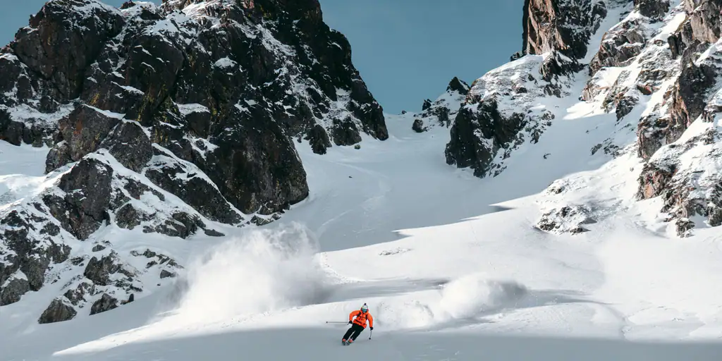
The resorts of half of Spain are preparing for skiing this week
The ski resorts of Madrid and Segovia, Teruel and the Cantabrian Mountains, wow, those of half of Spain, are preparing to open their slopes this week. The date marked on the calendar is Friday, January 20. Will it be possible?
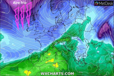
After losing the December Bridge, Christmas and the Three Kings due to lack of snow and warm temperatures, the cold finally arrives and heavy snowfall appears on the weather maps for the next few days.
In total, there are eleven Spanish alpine ski slopes that have not yet been able to launch the 2022-23 ski season (Valdelinares, Javalambre, Alto Campoo, Fuentes de Invierno, San Isidro, Leitariegos, Valgrande Pajares, Valdezcaray, Puerto de Navacerrada, La Pinilla and Valdesquí), as well as some like Port del Comte that has suffered to the limit.
Now, with normal temperatures for the season and waiting for natural snow, most of these stations have finally been able to start up their cannons.
According to meteorology experts, the first winter episode with capital letters with heavy snowfall comes from this same Sunday, “especially in the north of Spain” with snowfall forecast at almost zero level and significant accumulations in capitals such as Oviedo (25cm).
This Sunday the snow has already visited Pajares. A photo sent to us by Victor García Pérez from Pajares at 1,480m
The snow that should arrive will benefit not only the regions where it has barely snowed yet, but also others such as the Catalan, Aragonese, French Pyrenees, Sierra Nevada and Andorra, with the resorts where the slopes have been open since the beginning of December, but with much less snow than we all want.
Although on the web pages of the ski resorts of La Pinilla, on the Segovian slope of the Sierra de Ayllón, as well as that of Puerto de Navacerrada, between the provinces of Madrid and Segovia, there is no opening date for their slopes, They have everything ready to do it next weekend, from Friday the 20th.
 Snowfall forecast (cms accumulated in the total of the episode) in the Sierra de Guadarrama until Thursday at 7 am. in the morning. (Source: Meteosky)
The same is happening in Asturias, where Valgrande-Pajares, in Lena, and Fuentes de Invierno, in Aller, are confident that the forecasts will come true and they even set a possible start to the season, which would be before next weekend: Thursday 19 or Friday the 20th… although the north wind is unpredictable.
In the Cantabrian Mountains, the snowfall will be significant, the accumulations of several days are expected to leave thicknesses of more than 50 cm on the slopes and in some cases exceed one meter of snow.
This would allow the workers of the facilities -which are already available- to step on and redistribute the white mantle.
However, the forecast also contemplates the possibility of winds that could cause changes of planes.

snowfall forecast (cms accumulated in the total of the episode) in the Cantabrian Mountains until Thursday at 7 a.m. in the morning. (Source: Meteosky)
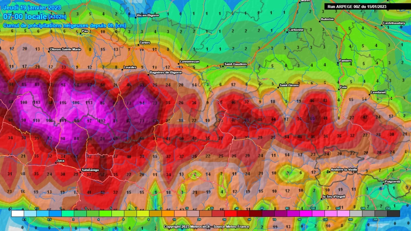
Weather is not an exact science and Thursday’s forecasts have changed a bit. For this Monday the level has risen in the Sierra de Madrid, while in the Cantabrian mountain range and in the Pyrenees they give a lot of snow, especially Aragon and Altos Pyrenees.

Snowfall forecast (cms accumulated in the total of the episode) in the Pyrenees until Thursday at 7 am. in the morning. (Source: Meteosky)
In the Pyrenees, Astún and Candanchú can exceed 80 cm of new snow in the total episode.
The height is only in danger at the Madrid stations on Monday night until Tuesday morning, which will be 1,800 m, to then drop rapidly.
Sierra Nevada will receive up to 20 cm of snow and, above all, a significant drop in temperatures that will allow it to produce snow and open more slopes.

This is how San Isidro is this Sunday. Cebolledo webcam image at 1,700m
In the Cantabrian mountain range it starts snowing today and doesn’t stop until Friday.
The maps indicate that the sum of centimeters can reach up to a meter of snow until Thursday 7 in the morning. And it will be very cold, even below -20 C at the highest altitudes. We’ll see.
What is clear is that all the seasons want to get going, but the north wind will be strong and may delay the opening for a couple or three days.
The snowfall should also allow the Nordic ski resorts to open, among the most affected to date due to their heights and, mostly, not having many canyons.
The start of the season was officially scheduled for December 2 and will last until April 9. The Christmas holidays have already been lost. But now, the tourism sector hopes to fill the accommodations on the carnival bridge, starting on the 17th of next month.
**As always, this is a simple forecast and we will know the reality in a few days. You have to follow it day by day.
More information:
Weather forecast for a calm weekend before the storm…