Weather forecast for Genoa and Liguria for the week of 21 to 25 November 2022
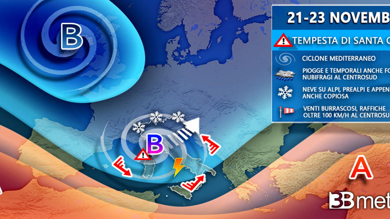
Bad weather returns to Liguria. “The passage of an intense perturbation over Italy on Tuesday has been confirmed, connected to a particularly deep cyclonic vortex that will move from the Tyrrhenian Sea towards the upper Adriatic”, warns the meteorologist from 3bmeteo.com Edoardo Ferrara, who explains “bad weather will not spare any region”.
On Monday, Arpal will carry out the usual assessments and decide whether to issue the alert and what colour. According to Sunday’s bulletin, the arrival of a front from France is expected on Monday 21 November, which will bring a rapid and marked deterioration. In the evening, rainfall in all areas, including downpours or thunderstorms of generally strong intensity on the Genoese area, La Spezia and the Savona coast, moderately on the rest of the region. In the evening winds from the north 50-60 km/h on the center and the eastern part of the west, with reinforcements and gusts on the ridges and at the mouth of the exposed valleys.
Tuesday 22 November the passage of the front will bring widespread rains with high quantities on the east and significant on the center-west. The rains will be accompanied by heavy showers/thunderstorms in the centre-east, associated with gusts of wind, and moderate in the west. Dusting of snow on the Savona valleys up to 600-800 metres. Phenomena in attenuation in the morning. Winds from the north 60-70 km/h on La Spezia and the inner valleys of the center of the region with gusts up to 100 km/h on the ridges and at the mouth of the exposed valleys. Rough or agitated sea with possible storm surges in the center and east.
The Arpal bulletin stops here. For the days to come we rely on 3bmeteo. On Wednesday the high pressure strengthens further, resulting in sunny weather with at most some scattered clouds at dawn. Specifically on the Riviera di Ponente and the Alps, skies were mostly clear or partly cloudy for the whole day; on the central coast and on the Apennines it was mostly a day with little cloud, except for the presence of scattered clouds in the morning; on the east coast day with variable weather, with more lightening during the afternoon. Weak winds from the north-western quadrants rotating to the south-eastern quadrants; Thermal zero around 2,300 meters. Western Ligurian Sea and Eastern Ligurian Sea very rough.
Liguria weather forecast for Thursday 24 November 2022
A field of high pressures embraces the Region guaranteeing stable and sunny weather, except for some harmless clouds arriving in the evening. Specifically on the Riviera di Ponente, the Alps and the Apennines, skies are likely to be clear or slightly cloudy for the whole day, except for the presence of some evening gatherings; On Rivers
Liguria weather forecast for Friday 25 November 2022
The depressive circulation, responsible for light rains in the first part of the day, loosens its grip favoring drier weather from the evening. Specifically on the Riviera di Ponente progressively increasing clouds with light rains from the afternoon; on the central Riviera very cloudy skies or overcast skies with light rains, absorbing from the evening with clear spells; on the Eastern Riviera very cloudy skies in the morning with light rain. Gradual attenuation of cloud cover and absorption of phenomena during the day; in the Alps progressively increasing clouds with light rains in the afternoon, absorbing in the evening; over the Apennines Very cloudy or overcast skies throughout the day, with light rain from the afternoon. Weak winds from the north-eastern quadrants rotating to the south-eastern quadrants; Thermal zero around 2200 meters. Western Ligurian Sea and Eastern Ligurian Sea moved. Central and Eastern Riviera were generally clear or slightly cloudy skies for the whole day. Weak winds from the north-eastern quadrants rotating to the south-western quadrants; Thermal zero around 2550 meters. Mar Ligure di Ponente and Mar Ligure di Levante from very rough to rough.