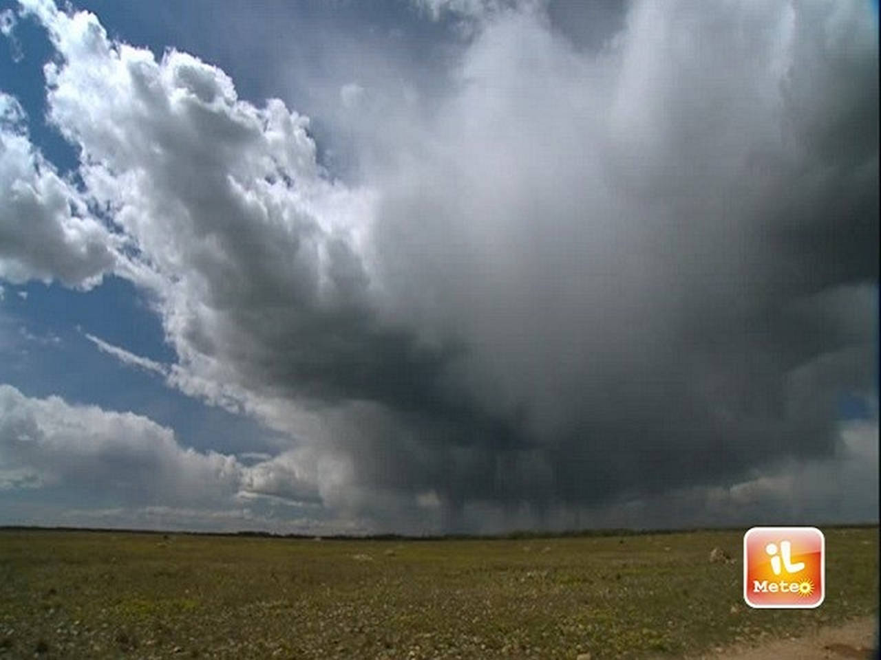
Bad weather: snow in Italy in Bergamo, in Sardinia and near Florence. Storm on the Roman coast: waves 3 meters high
Yesterday the great has targeted northern Italy. But the cold has already affected the whole country today. From Bergamo to the Sardiniadove ah snowed at low altitudes, as in Florence: those who expected a different beginning of spring were disappointed. But he won’t have to wait long because the situation should improve on Sunday. And next week, temperatures will rise again.
Low-altitude snow in Sardinia and Florence
In Sardinia, for example, it is still struggling to take off due to the disturbance coming from northern Europe. This morning the peaks of Nuorese and Ogliastra were whitened by a white blanket and it still continues to snow in the city in Nuoro but also in the hill towns of Barbagia. White flakes also in Southern Sardinia at hilly altitudes: from Esterzili to Sadali up to Parteolla just above 500 meters above sea level. Temperature close to zero even at Cagliari, where the mercury is rising to 4 degrees this morning. The white mantle also hit low-altitude centers such as Nuoro city where it started to snow around two o’clock last night and Lanusei in Ogliastra. In Atzara the mayor, “due to the particular meteorological situation”, closed schools of all levels. A similar decision was made by the Municipality of Ortueri with which it shares the school service, State snowplows 131 between Nuorese and Sassarese are in action, while at the Birori junction there is a heavy vehicle damaged on the roadway. The traffic police intervened on the spot. Snow and slowdowns also on the SS 389 Nuoro-Lanusei where the Anas vehicles are in action. The Polstrada recommends “not to travel without chains or especially suitable tires on the road sections of the Statali 389 and the provincial roads that refer to the localities of Fonnie Lanusei and towards the «Carlo Felice» at the height of the Campeda plateau until the emergency is over ». The snow in the night has also whitened the Consuma pass. The means of civil protection and traffic in the metropolitan city of Florence they are in action to allow road traffic.
Umbria and whitewashed peaks of the Apennines
The month of April brought cold and snow again to Umbria, especially on the highest peaks of the Umbria-Marche Apennines. Since yesterday evening Castelluccio di Norcia has been white again, as are the other places in the Sibillini mountains. The weather forecast of the Umbrian Civil Protection Functional Center predicted snow up to hilly citation in much of the region, especially in the Perugino area. The minimum temperatures in the last few hours have plummeted to zero and in some mountainous areas up to -7 degrees are recorded, as in the case of Forca Canapine. For tomorrow the snow level will rise to 800-1000 meters, from Monday the sun will return to shine.
Snow also in Bergamo
Snow began to fall this morning also on some areas of the Bergamo, even at low altitudes, starting from 600 meters. Among the main snow-covered resorts are Berbenno, in the Imagna Valley, just over 600 meters away, Foppolo and Valleve, where chains are needed to travel on the provincial road. At around 2,000 meters the snow reached about fifteen centimeters, already compacted due to the rising temperatures. Snow also in Piazzatorre, Ornica, Selvino and Colere, where today and tomorrow will be the last weekend on the ski slopes.
Bad weather in Liguria
Bad weather brought snow into the Spezzino also on the coast. It has been snowing since last night and the flakes have whitened the hills around the city. Snowfall also in Val di Vara with a few centimeters accumulated in the higher areas. Snow also on the Sciacchetrail foot race in progress at Five lands, with around 300 participants including the director of the Disney cartoon “Luca”, Oscar nominated, Enrico Casarosa. The snow has also returned to Santo Stefano d’Aveto (Genoa) where, however, the ski slopes remain closed, the lift up to Prato della Cipolla opened. Snow dusting overlooking the sea in Montallegro, on the heights of Rapallo. Also dusted on the mountains around Genoa.
The situation in Piedmont
Snow up to hilly summits, temperatures at -20 in the mountains, hailstorms and wind in Piedmont. It is the tail of winter that practically did not happen, with 111 days of drought. After yesterday afternoon’s hailstorms and windstorms, with damage to crops between the provinces of Cuneo and Turin, the thermometer plummeted last night: the minimum was 4.5 degrees in the center of Turin, 0.7 in Cuneo city. The lows in the mountains are very rigid: -24.9 on Monte Rosa, -19 in Ceresole Reale (Turin) in the Gran Paradiso park, -18.2 in Bardonecchia (Turin) in the Susa Valley. In the late morning of today the snow level will rise to 1,000 meters, in the afternoon an improvement in the weather is expected. The next night, however, will also be very cold.
Strong storm on the Roman coast
According to the seaside resorts, it is certainly the strongest storm in recent months that has been lashing the entire Roman coast for several hours. With the libeccio wind up to 80/90 km / h and waves up to three meters, an almost unwelcome surprise “out of season” for the seaside activities of Host, Fiumicino, Focene, Fregene, struggling for some time with serious problems of erosion, even if in the past there have already been storm surges in April. Someone, in view of Easter, had already begun to experience the beach but now the preliminary work is in vain. In some cases, the water laps the structures of the establishments. “This morning we are at 41 knots of wind but in the afternoon they are expected up to 52 – reports a seaside resort of Fregene – the peak intensity of the storm is expected for 17. Only tomorrow, therefore, it will be possible to actually verify what impact it will have had”. For some time now in Ostia Levante work has been going on for the defense of some stretches of coast, including reinforcement of and develops and nourishment, while in Fregene the Municipality of Fiumicino and the seaside resorts have agreed to start the work for the laying of the suffocated barrier, waiting for some time, for a stretch of 800 meters, starting from mid-September, after the bathing season. Last November a sequence of close storm surges caused a series of damage to bathing structures and exacerbated the erosion problems.
Rieti, still weather alert also for Saturday on the Reatino and snow at high altitude
Sea force 5-6: isolated Aeolian islands
Sea connections interrupted in the Aeolian Islands due to bad weather. Ships and hydrofoils are blocked in ports for the force 5-6 sea. The smaller islands have already had to deal with several canceled scheduled routes for 48 hours. Strong gusts of wind from the west blew over the archipelago all night with storm surges that hit the coasts and port structures. In the harbor of Lipari, three tankers of the Marnavi di Lipari company have anchored, while at the Sottomonastero port, in addition to the Siremar ship, the Green Fleet ferry that transports waste is also stopped. Also tomorrow the weather forecasts do not promise anything good and the seven islands risk being left without sea connections for another 24 hours.