11 best hikes in Sweden for each fitness level
With a long coastline, beautiful mountains, countless lakes and forests that cover a large part of its surface, Sweden is created for hiking. No matter where in the country you are, you will never be far from a track.
Virtually every landscape in Sweden has at least one long-distance hiking trail that shows the region’s most beautiful and interesting nature. These take anywhere from a few days to a month to go through but are divided into sections with simple entry and exit points. Most of the long-distance trails have windbreaks, huts and / or mountain stations where you can spend the night and in many cases buy or cook.
Sweden’s Public Law gives everyone the right to freely enjoy nature, as long as you follow some basic rules including leaving nature as you found it and not disturbing housing or property. Excellent public transport means that many trails, even seemingly remote ones, are within easy reach without a car.
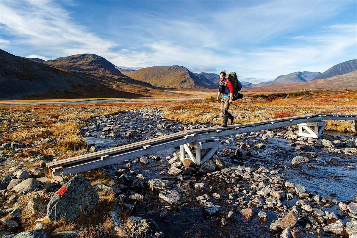
Kungsleden: best long-distance Arctic wilderness hike
Up to 280 miles (450 km), 4-31 days, difficulty varies
For spectacular alpine wilderness, you can not beat Kungsleden (Kungsleden), which runs through northern Sweden from Abisko to Hemavan, through four national parks and a number of fantastically beautiful landscapes. Some sections require significant hiking experience, but others are suitable for beginners with proper clothing and equipment.
If you want to hike only part of the Kungsleden, it northernmost part from Abisko to Nikkaluokta (108 km) is a good option. The landscape includes birch forests, alpine plateaus, green valleys, flowery meadows and Sweden’s highest mountain, 6879 feet (2097m) Kebnekaise. Count on seven days, plus an extra day if you want to top Kebnekaise.
The Jämtland Triangle: the best balance between wilderness and comfort
29 miles (47 km), 3 days, moderate
Suitable for all levels, this popular route connects three mountain stations at Storulvån, Blåhammaren and Sylarna in Jämtland, through birch forests and mountain meadows and over bare rock walls and gurgling streams, with mountains that rise dramatically in the distance. Since accommodation and restaurants are located at each station, you do not have to worry about carrying a lot of equipment with you, which allows you to concentrate on enjoying the scenery, which is spectacular. Make sure to book accommodation and meals at the mountain stations well in advance.
Get more travel inspiration, tips and exclusive offers sent directly to your inbox with ours weekly newsletter.
St Olavsleden: the best mix of nature and history
360 miles (580km), 1-29 days, difficulty varies
Scandinavia’s answer to the Camino de Santiago, this pilgrim route crosses Sweden and part of Norway from Selånger near Sundsvall to the tomb of Norway’s patron saint, King Olav Haraldsson, at Nidaros Cathedral in Trondheim. After claiming the Norwegian crown in 1020 and trying to introduce Christianity, Olav was driven into exile. In 1030 he landed on Sweden’s Baltic coast, erected a cross in Jesus’ name and walked all the way to Norway to regain the throne but was killed in battle a few weeks later.
St Olavsleden follows in the footsteps of the saint king on a beautiful journey filled with nature and historically interesting places. If you only want to hike part of the trail, you can easily mix walking days with road or rail travel, or do a day hike on almost any of the stages.
Skuleskogen: the best hike for interesting geology
4-7.5 miles (7-12 km), 3-6 hours, hard
Since the end of the last ice age, the shoreline at Sweden’s High Coast has risen about a third of an inch (8 mm) per year — about 984 feet (300 m) in total — which makes it both scenic and a unique example of geological forces at work. A highlight of the region is Skuleskogen National Park, the center of which is Slåttdalsskrevan, a deep, steep abyss only 23 feet (7m) wide. From the park’s southern entrance, go north on the Högakustenleden. You can stop at it directly to Slåttdalsskrevan or take a turn over Slåttdalsberget for fantastic views of forest, coast and islands. From Slåttdalsskrevan you can either turn and back or, for a longer loop hike, continue north and turn off the Högakustenleden to follow the coast back to the park entrance. Uneven terrain and varying heights make this a rather demanding hike.
Tyresta: the best wilderness near Stockholm
Distances vary, 1 hour to a full day, light-moderate
For wild nature within easy reach of Stockholm, look no further than Tyresta National Park, southern Sweden’s largest primeval forest area and less than an hour from the center by public transport. Here gnarled pines and tall spruces rise over rocky ground covered with moss and lichens in a mysterious landscape dotted with sparkling lakes. At the entrance to Tyresta Village you will find a visitor center and the starting point for various trails, including a 5 km long trail that is suitable for prams. A longer route combines several shorter trails to a loop around several of the park’s lakes.

Bohusleden: best long-distance wilderness hike in southern Sweden
Up to 230 miles (370 km), 3 hours to 27 days, medium hard
Bohuslän, north of Gothenburg, is known as a large coastal destination with picturesque cities that cling to rocky beaches. This long distance shows another side of the region, meandering through nature reserves and other scenic areas inland from Lindome to Strömstad.
The southernmost parts, around Gothenburg and Kungälv, can be made as unpretentious day trips, with easy access by public transport. As you continue north, the trail becomes more remote and challenging but rewards the effort with deep forests, secluded lakes, high cliffs and panoramic views. The stretches through Svartedalen and across the Kynnefjäll Plateau are particularly wild and scenic.
Stone door: best for easy archipelago access
Distances vary, 1-4 hours, easily
On the Södermanland coast south of Stockholm, the fantastic The stone door nature reserve is one of the easiest places to get out in the archipelago on foot. Forested paths and suspension bridges for pedestrians lead to small islands with smooth cliffs that slope towards the sea perfekt— perfect for a picnic or a refreshing dip. From some of the outer islands you can see the boat traffic passing by and perhaps navigating the narrow gap between the mainland and the island of Krämpö. A visitor center at Aspnäset (May to September) has exhibitions about the Baltic Sea, a panoramic tower and a 2.5 km long interpreting trail.

Omberg: most varied day hike
Distances vary, 2-9 hours, light-moderate
Steeped in history and legends, the steep Omberg rises 862 feet (262 m) from the eastern shore of Sweden’s second largest lake, Lake Vättern. A hike to its summit, Hjässan, is one of many great alternatives in the wonderfully varied Omberg Ekopark, once a private royal hunting ground and later a state forest school. If you have time, a full day hike on the Östgötaleden is an excellent way to experience the park’s varied nature and many of its attractions. Starting at Ecopark Center in Stocklycke, the circuit follows the lake shore northwards, then turns inland and winds through wildflower meadows, moors and forests, passing caves, old mountain forts, a 900-year-old quarry and medieval monastery ruins, before circulating back along the shore to Stocklycke .
Klint coastline: best for dramatic coastline
18.6 miles (30 km), 1-2 days, light-moderate
One of Sweden’s newest organized hiking trails, this route tracks Gotland’s northwest coast from Björkume nature reserve north of Lummelunda to Hallshuk, the island’s northernmost point. The trail goes through fishing villages and varied nature, including beaches, six nature reserves, flower meadows and secluded coves. Highlights along the route include Gotland’s highest rauk (sea stack), near Lickershamn, and Häftingsklint, a 98-foot (30m) cliff with sweeping views. You will probably also see lots of birds along the way med— luckily you can even see a sea eagle hovering over the rocks.

Prince Bertil’s Trail: best semi-urban coastal walk
11 miles (18 km), 5-6 hours, easy
The beloved uncle of King Carl XVI Gustaf, Prince Bertil was Duke of Halland until his death in 1997. Dedicated to his memory, this walkway in his landscape is an enjoyable hike through varied nature in and around Halmstad on Sweden’s southwest coast. Starting at Halmstad Castle from the 17th century, the trail runs from the center to the sea, then winds along the coast past beaches, cliffs, marinas and cultural-historical sites to Tylösand, where Prince Bertil and his wife, Princess Lilian, spent several summers. From there, the path turns inland, passing golf courses before reaching Möllegård nature reserve. Most of the trail is wheelchair accessible, and there are bus stops at various places along the route.
Kullaberg: best for rugged coastal landscapes
10.6 miles (17.2 km), 8-9 hours, moderate-hard
Northwest of Helsingborg, the triangular Kullaberg Peninsula slopes steeply towards Öresund and Skälderviken. For a beautiful full day adventure, hike part of Kullaleden between the idyllic coastal villages Mölle and Arild, through deciduous forests and along the coast via the tip of the peninsula, where you will find Sweden’s most powerful lighthouse and a visitor center about Kullabergs nature reserve. If the sea is calm, you can even spot seals and porpoises.
You can hike the trail in both directions, but the stretch along the north side of Kullaberg (between Arild and the lighthouse) is more challenging. If you have the time and energy, there are many possible detours down to the beach (and back up).