The milestones that tell the ties between Rimini and San Marino
Follow the stone tracks to go back to a part of the ancient road to San Marino that affected our urban center. They deserve a conservative restoration.
Often some stones tell us something, but we don’t always manage to listen to them. Two of them want to tell us the story of a road that no longer exists or, rather, no longer has its ancient function, even if it still exists as a route. It is a part of the ancient road to San Marino, which involved our urban center.
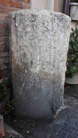
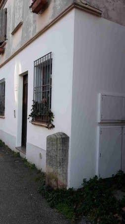
How many times have we passed in Via Saffi, near the public fountain, without realizing that there is an anonymous stone stone embedded in the sidewalk or, even if we see it, we do not understand what it can be about or include.
The stone, presumably limestone ruin, is ravaged and corroded by time, as well as being chipped and badly patched at its base with a showy, merciless gray cement mixture. It almost seems that he is standing there disconsolately, waiting for someone to notice him or give him the attention he once had.
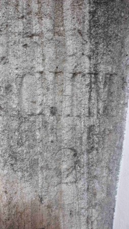
Trying to understand its origin, its function and the almost illegible writing on both sides, it turns out that they report: “CHIL[OMETRO] 3 “; a milestone therefore.
The milestones in distant years constituted a reference point for travelers who were along a certain route and knowing the total distance to the point of arrival, as they met them, therefore knowing how much was left to reach the goal.
They had very ancient origins since the time of the Roman consular roads; then, with the advent of road maps, and later with GPS navigation systems, they fell into complete oblivion, completely losing their importance. In addition, changes in the road layouts, often frequent over time, have contributed to their abandonment.
But the question that catches the curiosity is the following: which kilometer three are we talking about? That is, what were the previous indications for climbing the previous milestones, and which road did they refer to?
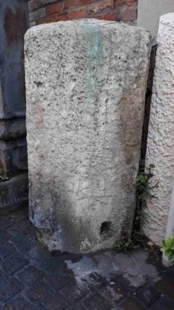
Let’s start with a simple consideration. Via Saffi, formerly called Polverara, was part of the road that led to San Marino after having turned left into today’s Via Monte Titano. Then a milestone related to it, of which the previous one can still be seen in better conditions in Via B. Gueritti. Same shape, same stone, but easily legible in its indication “CHIL 2”.

Taking a measurement with Google Maps, net of the normal usual tolerances of the case, between the two milestones there is a distance of one kilometer.
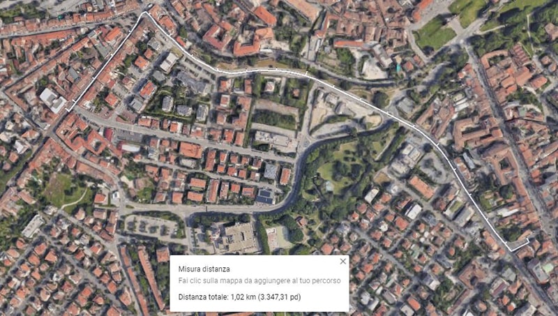
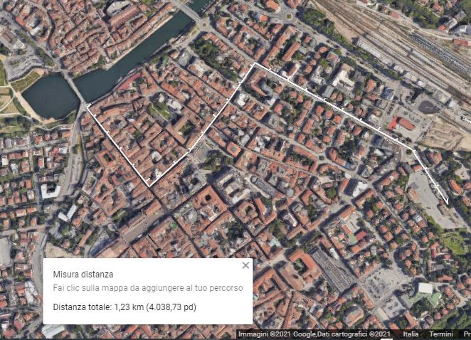
From kilometer 2 to 3. Measurement with Google Maps.
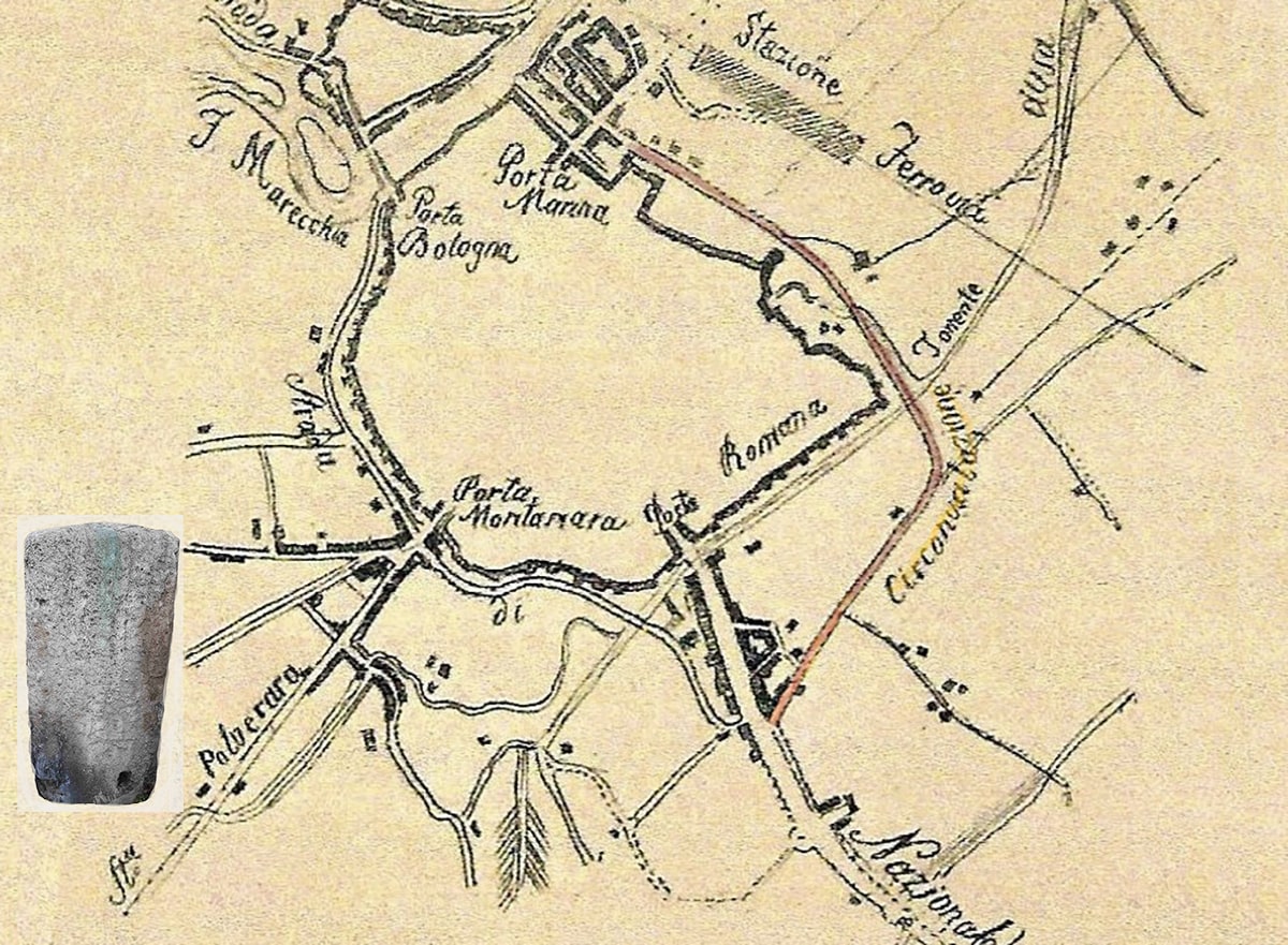
In a map of Rimini dated 1916 published by TCI, the Via Gueritti and the current Southern ring road consisted of the then National Road of San Marino; National, mind you, because the classification is important. In that year it crossed the Via Flaminia, to enter Via Tripoli proceeding towards the sea. In the same, the turning point in Borgo Sant’Andrea to reach the destination of Monte Titano is highlighted.
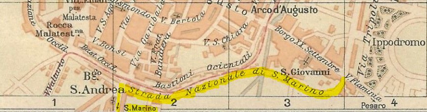
Map of Rimini from 1916 – Source Touring Club Italiano.
To understand where to be. It clearly indicates the path classified as “Via Nazionale San Marino”, consisting of the current Via Roma and the final part of Via Tripoli.
Reconstructing that itinerary, the Miliari still present have been shown in red, while those (probable) no longer exist in green; always with a distance between them of one kilometer, calculated as usual with Google Maps and thoughtful the aforementioned tolerances. Even the name of the street is clear up to the intersection with Corso Umberto I, after which the route becomes a hypothesis supported by the width of the roads that connected it to the Tiberius Bridge.
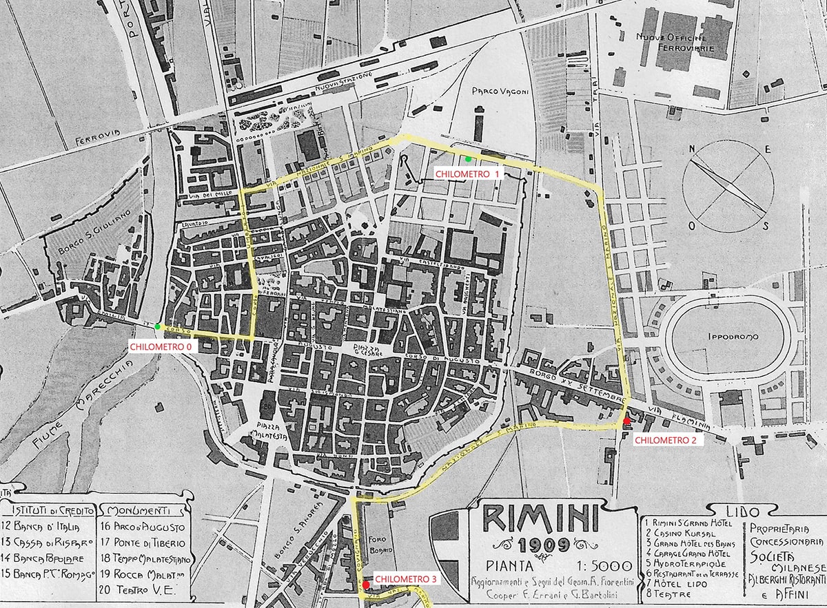
Map of Rimini from 1909 – Fonte Rimini City as History – Giorgio Conti, Pier Giorgio Pasini. Year 2000 Vol. 2, p. 194.
From kilometer 0 to 1. Measurement with Google Maps. From the end of the Tiberius Bridge, near the Amphitheater.
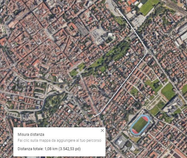
From kilometer 1 to 2. Measurement with Google Maps. From near the Amphitheater in Via Gueritti.
We can therefore reasonably think that the road to San Marino started at the end of the Tiberius Bridge; after all, it is at that point that the Via Emilia arrives.
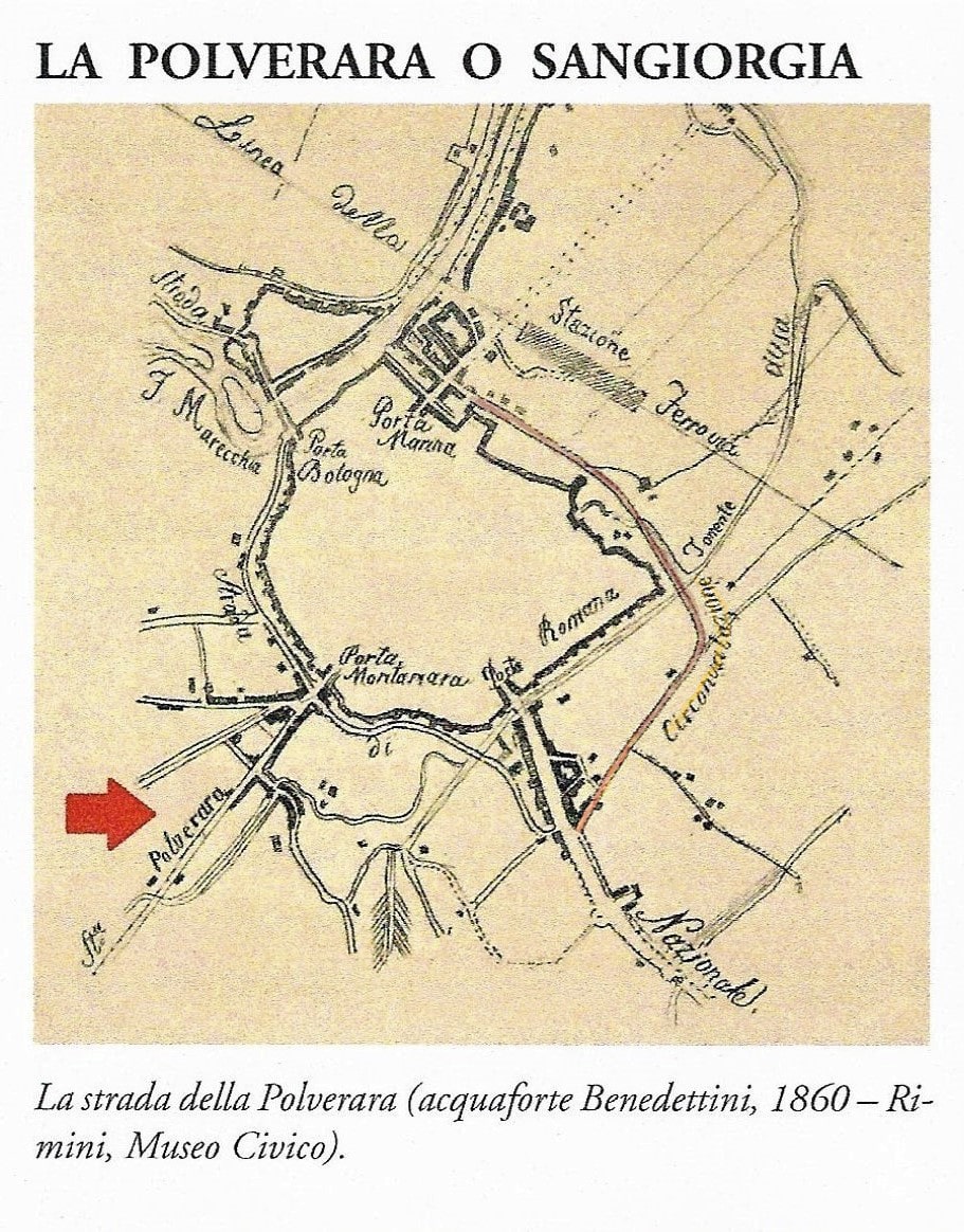
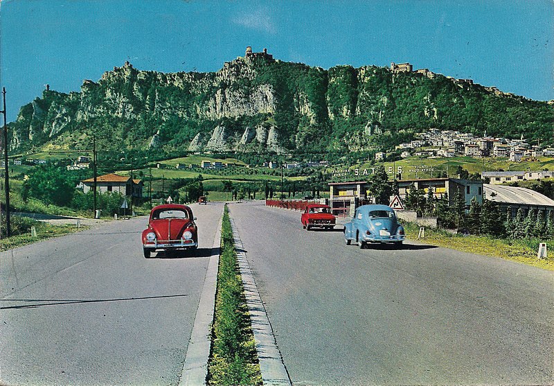
However, it must be said that previously in a map of Rimini of 1860, this road route was indicated as “Circonvallazione”; a farsighted example of urban planning of that time, far from the current creative improvisations on the subject, especially children of the last twenty years.
Then in 1959 work began for the construction of the new state road SS72, which was inaugurated in November 1965; but that’s another story. (source: by Techograf Palermo – Personal postcard scan, public domain).
But let’s go back to our milestones. In 1865 the Municipality of Rimini decided to place those signposts in the municipal streets. In particular, via Polverara, today Saffi and Covignano, it was included in the project N ° 541 of 02/12/1865 by the IV Public and Ornate Works Office signed by the engineer Luigi Cervellati, which had as its object: “Project for to place milestone stones on the municipal roads, and stone bollards in Polverara “. In that case in the number of 5 at the unit cost of Lire 9.50, and for a total cost of Lire 47.50.
The artefacts, in San Marino stone, were completely different from those attributed to the National road that led to the Titan, moreover posthumous to that date. While the former had a rectangular plan with rounded corners, and a solid shape with variable width, as can be seen from the drawings attached to the project, those in question are still in the shape of a solid with a triangular base; therefore two different shapes, for two different categories of roads, National and Municipal. Furthermore, if the installation date is known for the former, it is not known as regards the latter; but, on the basis of the aforementioned map of 1909, it can reasonably be assumed that they will be affixed in the early 1900s, therefore to the municipal stones.
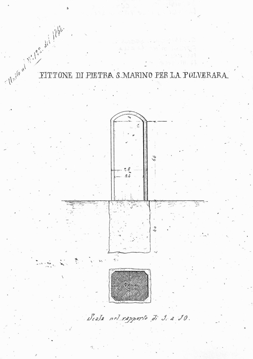
Milestone for municipal roads, from the 1865 project.
The two Miliari found a part, even if minimal, of our local history, and in this case of the relationship that has always linked Rimini with the Republic of San Marino.
It would therefore be advisable to make them the subject of a conservative restoration, perhaps by placing a small plaque near them that remembers their function. Overall it would be a small expense, but of interesting social value of our past and for the preservation of testimonies that are gradually lost in the memory of those who lived through those periods.
Because history is also made up of small things, of everyday life, and of respect for those objects that were once of great use but now obsolete and forgotten. Let’s adopt those Miliarius then!
I am not a historian but intrigued by those “stones”, I have also developed this little research with the help of ancient maps of the city.
Further news, corrections and possible reports of other similar existing milestones will therefore come well, but if anything also those of the ancient Polverara, which can also be sent to [email protected].
I thank the excellent professor Giovanni Rimondini who offered me some interesting ideas, with which I was able to carry out this little research.