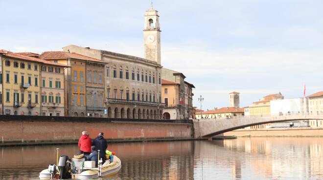
Navigable Arno in Pisa: the surveying operations of the river bed have been completed
The project to make the Arno navigable in Pisa comes to life with the execution of the first survey phases of the river bed. The operations carried out by the Terra & Aria company in Lucca have just finished, which had been awarded the topo-bathymetric survey of the river bed with the use of an equipped nautical vessel, thanks to which it was possible to scan the entire bottom of the Arno from the mouth to the bend of Cisanello for a distance of 18.5 kilometers.
This was the first of the seven external design assignments entrusted by the Municipality of Pisa to architectural and engineering firms to carry out surveys, feasibility studies, executive projects of the hydraulic works and environmental impact assessments, preliminary to the construction of the new road. of water.
“The scanning conducted in these days – explained the commissioner for public works and navigability Raffaele Latrofa, during the press conference to present the reliefs along the Arno – ci will allow in about a month to have a graphic rendering in three dimensions of the entire stretch of the Arno that extends into the municipal area. What we are presenting today is therefore the first step towards planning the hydraulic works necessary to make the Arno navigable. The 3D model that we will soon have will allow us to calculate the volumes of sand to be gained in the bottom, and therefore to evaluate the dredging works to be carried out in the various sections of the river “.
“Beyond the river bed – continued the commissioner – in this phase the whole part of the Arno river and the quays is also scanned, therefore we will have a complete section of the Lungarni river, from palace to palace, which will also be useful for planning the subsequent developmental works of the project, such as the construction of the Scalo della Cittadella, the floating piers at the San Rossore Park, and all the other works related to the theme of city branding and the tourist promotion of navigability “.
“I remember – concluded Latrofa – that from the presidency of the council of ministries we had the financing of the entire amount, equal to over 320 thousand euros, which was used to draw up the executive project of the navigability, to which the Municipality has added another 67 thousand euros. Today’s executive project is practical, today this constitutes the first step, and in 2022 we will be able to deliver the project ready to the Presidency of the Council of Ministers. At that point, start with the subsequent phases, which will be those of the beginning of the works to create the real works. At the end of the works, as a last phase, the navigability decree of the Arno will be issued by the Region, which is expected from the end of the 19th century ”.
The technicians of the company in charge of carrying out the survey then explained, together with the manager of the Municipality of Pisa Fabio Daole, the methods of execution of the interpretations: “The boat is equipped with a multi-beam sonar that is submerged underwater and sweeps the bottom, detecting depth at 480 points, with a 120 ° opening angle. Traveling along various strips parallel to the river, we are able to collect all the depth data of the riverbed. The result that we will have at our disposal will be a georeferenced model model, since the system also makes use of two GPSs that transform points into global coordinates. This system is controlled by two monitors which are taking measurements in real time “.
“What we will provide to the Municipality – the Terra & Aria technicians continued to clarify – is a digital terrain model, consisting of clouds of georeferenced points, which are then translated into a color map where you can see the different depths. In addition to this, the laser-scan survey of all the banks was also carried out, and finally we will continue along the Arno river, on the road part, passing here with the scanner, in order to integrate also with the part of the buildings and all that is around to the river. Then all the reliefs will be inserted and reassembled in the final elaborate, or in the 3D reconstruction in which we will see everything: the buildings, the road, the banks, the quay and the riverbed where you go underwater “,