Austria: Weather review winter 2021/22 – mostly very mild
Mostly little snow in the lowlands
The mild weather has an impact on the snow conditions in the lowlands. “Below 1,000 meters above sea level, there were significantly fewer days with snow cover and less fresh snow in almost all federal states this winter than on average in the last 30 years.
The deviations were greatest in Lower Austria, Vienna and Burgenland with around 40 to 70 percent fewer snow cover days and fresh snow totals,” says Orlik, “only in Carinthia and Salzburg was there more fresh snow and snow cover days than the long-term average, with a plus depending on Region of around 10 to 50 percent.”
Above 1,000 meters above sea level, the number of snow cover days was in the range of the long-term average and the total amount of fresh snow was 5 to 15 percent below the mean.
Significantly fewer ice days at all altitudes
The winter of 2021/22 brought very few ice days (temperature below 0 degrees all day). Below 500 meters above sea level there were 70 to 100 percent fewer ice days than in an average winter. Innsbruck, for example, did not record a single day of permafrost, in an average winter there are eleven ice days here. Above 1,000 meters above sea level, the number of ice days in Austria was around 30 percent below the long-term average.
From -20 to +22 degrees
The ZAMG weather station Graz Straßgang (ST) recorded the highest temperature of this winter with 22.1 degrees on February 17th. It was coldest in the inhabited regions with -20.3 degrees on January 7th in Radstadt (S).
Partly dry in the south
In the Austria-wide evaluation, the amount of precipitation, taking into account the forecast up to the end of the month, is just below the long-term average (-9 percent). In some regions, however, the winter was far too dry. So field in East Tyrol and Upper Carinthia, especially along the Carnic Alps and the Karawanken, 30 to 60 percent less precipitation than in an average winter. There was 15 to 30 percent more precipitation than the average in the Bregenzerwald and in places in the Pongau, Tennengau and Salzkammergut.
Partly quite sunny
In the Austria-wide evaluation, the duration of sunshine was eight percent higher than an average winter. The sunniest regions were found in western and eastern Styria (+30 to +55 percent). There was significantly less sunshine than in the average winter in Tennengau, in Flachgau and in the Salzkammergut as well as on Upper Austria’s border with Germany (-10 to -30 percent).
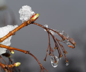
Phenology: first signs of spring bloom
The mild weather since the beginning of the year has boosted the phenological development of the plants. In some regions the hazel catkins have already faded and fallen off and the snowdrops are in full bloom. In the willow, the anthers are beginning to become visible, turning the pussy willows yellow. This means that the development of the plants today is about two weeks ahead of the long-term average, but probably in the range of what we have experienced in recent years.
The early start of vegetation is associated with a certain risk of late frost for agricultural crops. In the Vienna area, for example, the flower buds of the apricot trees are already red, which makes the progressive frost softening visible.
Winter 2021 in detail
Note: The textual description and the table values refer to the new normal climate period 1991-2020, unless a different normal climate period is explicitly referred to.
temperature
The temperature level of the winter was very high over the entire course and there were no cold waves with several days of permafrost. Winter was particularly mild around the turn of the year with daily maximums of around 18 °C and from the second half of February, which brought maximum values of up to 22 °C in the south-east and east.
The mild weather conditions can be seen, among other things, in the number of ice days (Tmax below 0 °C). Especially in the non-Alpine regions of the federal territory, but also in the lower Inn Valley and in the Rhine Valley, there were 70 to 90 percent fewer ice days and in some cases up to 100 percent fewer ice days, based on the average for 1991-2020. For example, there was no ice day in Innsbruck. The average here is 11 ice days. This winter, below 500 m above sea level, the deficit of ice days was 77 percent, at altitudes of 500 to 1,000 m it was 44 percent and above 1,000 m it was 30 percent.
The largest temperature deviations this winter occurred from Upper Austria to Central Burgenland. In this considered war, the winters, based on the 1991-2020 mean, were 2.0 °C to 2.7 °C warmer. But also in parts of Upper Styria and in East Styria as well as in southern Burgenland it was clearly too warm with anomalies of 1.5 to 2.0 °C.
In the Salzkammergut, in southern Upper Styria and western Styria, as well as in the Rhine Valley and in the Tyrolean Oberland, the winter was 1.0 to 1.5 °C warmer. In the Tyrolean Unterland, Pinzgau, Pongau and parts of Carinthia, there are anomalies between 0.3 and 1 °C. In the southern part of Carinthia, the winters are average, with deviations of -0.5 to 0.3 °C.
In historical comparison, this winter is one of the warmest in Austrian measurement history. With a deviation of +2.6 °C to the 1961-1990 mean, the winter of 2021/2022 was the eighth warmest of the past 255 years (HISTALP lowland data set). It is now the 16th winter in a row that shows a positive temperature anomaly compared to the penultimate climate normal period (61-90). It was not quite as extremely warm on the mountains and the anomaly to the mean 1961-1990 was +1.7 °C here.
January and February in particular have contributed a great deal to this mild winter. These two months were 2.9 and 3.0 °C too warm, as measured by the 1961-1990 mean. But December was also significantly warmer than the 1961-1990 average, with an anomaly of +1.6 °C.
precipitation
There were larger negative deviations from the long-term mean in the Waldviertel and Weinviertel, in Burgenland, in the Semmering area, in western and southeastern Styria, East Tyrol and parts of Upper Carinthia, as well as in the Paznaun and Upper Inn valleys. The anomaly locations in these regions are predominantly between -15 and -35%.
In East Tyrol and Upper Carinthia, and especially along the Carnic Alps and the Karawanken, the winter was clearly too dry, with deficits of 30 to 60 percent. 15 to 30 percent more precipitation falls in the Bregenzerwald and in certain areas in the Pongau, Tennengau and Salzkammergut. In the remaining parts of the country, the precipitation anomalies are between -15 and +15%.
The winter precipitation deficit was mainly due to January, which brought 35 percent less precipitation. In December there was a slight increase in precipitation of +2 percent and in February there was a significant increase of +15 percent.
Sun
Sunshine conditions were slightly above average this winter. The area mean deviation from the 1991-2020 mean was +8 percent. The relatively sunny January, which brought 15 percent more sunshine, made a major contribution to the plus. February showed a plus of 7 percent.
Above-average sunny conditions were mainly in the south, south-east and east of the country. In the southern parts of East Tyrol and Upper Carinthia, in Lower Carinthia, in Styria south of the Mur and Mürz, as well as in the eastern part of Lower Austria and in Vienna, there was an increase in direct sunshine of 10 to 30 percent.
In western and eastern Styria and in Burgenland it was exceptionally sunny with anomalies of +30 to +55 percent compared to the 1991-2020 mean. There was significantly less sunshine in Tennengau and Flachgau, in the Salzkammergut and on the Upper Austrian-German border. Here the deficits are between -10 and -30 percent.
Winter 2021/2022: Overview of the federal states
Vorarlberg
Precipitation deviation 13%
Temperature deviation +0.8 °C
Sunshine Duration Deviation -4%
Maximum temperature Rohrspitz (395 m) 17.9 °C on 18.2.
Minimum temperature (summit/high alpine) Lech (1,442 m) -20.0 °C on 12.2.
Lowest temperature below 1,000 m Schoppernau (839 m) -17.4 °C on 22.12.
highest seasonal mean air temperature Bregenz (424 m) 3.1 °C, dev. +1.3°C
maximum sunshine duration Sulzberg (1,016 m) 293 h, dev. no
Tyrol
Precipitation Deviation -16%
Temperature deviation +0.9 °C
Sunshine duration deviation 5%
Maximum temperature Innsbruck-Uni. (578 m) 17.8 °C on 17.2.
Temperature low (summit/high alpine) Brunnenkogel (3,437 m) -22.9 °C on 21.1.
Temperature low below 1,000 m Lienz (661 m) -16.6 °C on 23.12.
highest seasonal average air temperature Innsbruck-Uni. (578 m) 1.7 °C, dev. +1.2°C
maximum sunshine duration Brunnenkogel (3,437 m) 416 h, dev. no
Salzburg
Precipitation Deviation 0%
Temperature deviation +0.8 °C
Sunshine Duration Deviation -5%
Maximum temperature Golling (490 m) 17.5 °C on 17.2.
Temperature low (summit/high alpine) Sonnblick (3,109 m) -20.7 °C on 21.1.
Temperature low below 1,000 m Radstadt (835 m) -20.3 °C on 13.2.
highest seasonal mean air temperature Mattsee (502 m) 2.8 °C, dev. +2.5°C
maximum sunshine duration Sonnblick (3,109 m) 388 h, dev. +3%
Upper Austria
Precipitation deviation 5%
Temperature deviation +1.9 °C
Sunshine Duration Deviation -5%
Maximum temperature Micheldorf (459 m) 18.1 °C on 3.1.
Minimum temperature (summit/high alpine) Dachstein glacier (2,520 m) -20.1 °C on 7.1.
Lowest temperature below 1,000 m Windischgarsten (600 m) -13.1 °C on 13.1.
highest seasonal mean air temperature Linz (262 m) 3.1 °C, dev. +2.1°C
highest sunshine duration Feuerkogel (1,618 m) 265 h, dev. -fifteen %
Lower Austria
Precipitation Deviation -16%
Temperature deviation +2.2 °C
Sunshine duration deviation 12%
Maximum temperature Berndorf (337 m) 20.6 °C on 17.2.
Minimum temperature (summit/high alpine) Rax/cable car (1,547 m) -13.0 °C on 21.1.
Lowest temperature below 1,000 m Lunz/See (612 m) -12.8 °C on 13.1.
highest seasonal mean air temperature Gumpoldskirchen (212 m) 4.0 °C, dev. +2.6°C
maximum sunshine duration Mönichkirchen (991 m) 348 h, dev. +4%
Vienna
Precipitation Deviation -9%
Temperature deviation +2.5 °C
Sunshine duration deviation 19 %
Maximum temperature Vienna-Unterlaa (200 m) 18.6 °C on 17.2.
Lowest temperature (summit) Vienna-Jubiläumsw. (450 m) -7.7 °C on 12.1.
Temperature low Vienna-Mariabrunn (225 m) -8.0 °C on 8.1.
highest seasonal mean air temperature Vienna-Inner Stadt (177 m) 5.2 °C, dev. +2.6°C
longest duration of sunshine Vienna-Jubiläumsw. (450 m) 260 h, dev. no
Burgenland
Precipitation Deviation -19%
Temperature deviation +2.1 °C
Sunshine duration deviation 34%
Maximum temperature Eisenstadt (184 m) 21.1 °C on 17.2.
Temperature low Lutzmannsburg (201 m) -9.4 °C on 10.12.
highest seasonal mean air temperature in Eisenstadt (184 m) 4.0 °C, dev. +2.9°C
maximum sunshine duration in Wortenberg (404 m) 385 h, dev. no
Styria
Precipitation Deviation -8%
Temperature deviation +1.3 °C
Sunshine duration deviation 17%
Maximum temperature Graz-Strasgang (357 m) 22.1 °C on 17.2.
Minimum temperature (summit/high alpine) Stolzalpe (1,291 m) -12.0 °C on December 8th.
Lowest temperature below 1,000 m in Zeltweg (678 m) -19.6 °C on December 8th.
highest seasonal mean air temperature Laßnitzhöhe (530 m) 2.5 °C, dev. +2.2°C
highest sunshine duration Graz Uni. (367 m) 428 h, dev. +34%
Carinthia
Precipitation Deviation -19%
Temperature deviation +0.5 °C
Sunshine duration deviation 14%
Maximum temperature Obervellach (688 m) 17.5 °C on 17.2.
Minimum temperature (summit/high alpine) Villacher Alpe (2,117 m) -13.7 °C on 7.1.
Lowest temperature below 1,000 m Weitensfeld (704 m) -18.7 °C on December 8th.
highest seasonal mean air temperature Döllach (1,071 m) 0.5 °C, dev. +1.7°C
maximum sunshine duration Villacher Alpe (2,117 m) 514 h, dev. +15%
weather review
> To the weather review for Austria
weather forecast
> To the current professional weather forecast for Austria
zamg