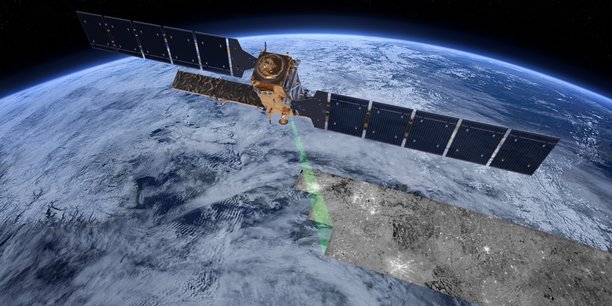
how Toulouse makes the mass of data on the state of the Earth bear fruit
“Toulouse is not just Airbus, it is also a center that operates ocean surveillance for Europe. Unlike other entities that work near the ocean, our company is not located by the sea but despite everything, we won this European delegation “, recalls Fabrice Messal, user experience manager at Mercator Océan.
Founded in the mid-1990s by five major national players in operational oceanography (CNRS, Ifremer, IRD, Météo-France and Shom), Mercator Océan won in November 2014 a call for tenders from the European Union with 144 million euros to provide the Copernicus Maritime Service, a public (and free) ocean observation service across the globe. A seven-year contract which has just been renewed for an additional seven years.
“Mercator Océan is the conductor of this service which provides both dataéobservation from dataésatellites but also information measureéare at sea in situ. We capture three types of parameters: océa physics with paramsèvery like salinityé, temperatureénature and sea currents; océa green with all dataées biogéochemicals, chlorophyll, nutrients, dioxygèborn ; finally the océa recovered white all dataésea ice (pack ice).
The service also delivered modsèocéanics. In the same way that there are modsèm’sétéorology for présee the time, we distribute modsècapable of predicting the state of the oceans over the next ten days, ”explains Fabrice Messal.
Improve the routing of boats
The latter presented this service in detail at the Copernicus Days event organized until October 24 at the Cité de l’Espace in Toulouse. Available free of charge, Copernicus data is used by many companies for commercial purposes.
“A large group of French shipowners uses our products to improve the maritime routing of its boats and at the same time save fuel and time at sea and reduce the risks for people on board ships. In another field, some startups are using Copernicus to work with aquaculture farms. renewable marine, this is data that will be used to determine the location of tidal turbines or wind turbines at sea, “he continues.
For Mercator Océan, this huge European contract increased the workforce from 60 to 80 employees in the space of seven years.
Democratize access to the Copernicus portal
The company is not the only one in Toulouse to make the mass of Copernicus data grow. In a completely different register, CS Group is part of the consortium which won a contract in 2017 to develop the Support for Copernicus Research users.
“Thanks to the Copernicus program, a great deal of data is available free of charge. On the other hand, to use it, you must have a certain level of knowledge in remote sensing but also tools to process the data. Just to visualize a Sentinel 2 satellite image requires software. specific “, points out Eric Guzzonato, program director in the space division of CS group in Toulouse.
His team has developed three types of services to democratize access to Copernicus data: facilitate access to data from the cloud, a support cell pour rélay eggs questions from these novice users and help them in their work. And finally, a training program for Dédeveloper of applications from dataées using open source software. “Of the 3,000 users of our service in four years, 60% come from universities, 20% from research and 20% from private companies”, valued Eric Guzonato. For example, the service helped the Centrale Supélec Paris establishment to train around 100 students in remote sensing to use the Copernicus portal.
“That’s the whole point of the Copernicus program. As the service is free, it can be used by businesses as well as by those who have just an idea. Through the European Cassini program, we really want to help those who have an ideae to go to the commercial stage “, recalls Mauro Facchin, vshef of the Earth Observation Unit at the European Commission. As part of this Cassini initiative, a hackathon is organized for example in early November in Toulouse by the Aerospace Valley competitiveness cluster, calling on students, entrepreneurs and professionals to find solutions for “connecting the Arctic region”.
Refine farmers’ need for fertilizer
Finally, Copernicus data feeds paid services developed by major operators. In Toulouse, Airbus Defense and Space launched a service to farmers called Farmstar at the end of the 1990s to enable them to refine the fertilizer needs on their plots of wheat, barley or rapeseed. The arrival of the Sentinel-2 satellites, developed by Airbus as part of the Copernicus program and put into orbit between 2015 and 2017, has made it possible to push the service further.
“Farmstar uses both satellite images to know the nutritional status of the plant and an agronomic model to transmit a recommended dose of nitrogen fertilizer. Before the Sentinel-2, we used data from the Spot satellites, for example. These aircraft were equipped with a sensor to measure chlorophyll. allow replace aerial images because satellites are able to provide vses information on the content of chlorophyll data. The other contribution of Sentinel-2 is the frequency of passage (every five days on average with satellites 2A and 2B ) but also to be able to cover many plots in a single image “, indicates Emmanuelle Paganelli, Farmstar project manager at Airbus.
Today, Farmstar has 13,000 subscribed farmers (for a suggested price of 11 euros per hectare per year) and has covered 630,000 hectares during the 2021 measurement campaign.